Project Phase:
Exploration
Commodity:
Uranium
Size:
8,582 acres
Location:
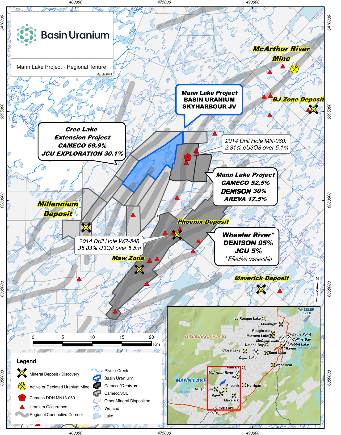
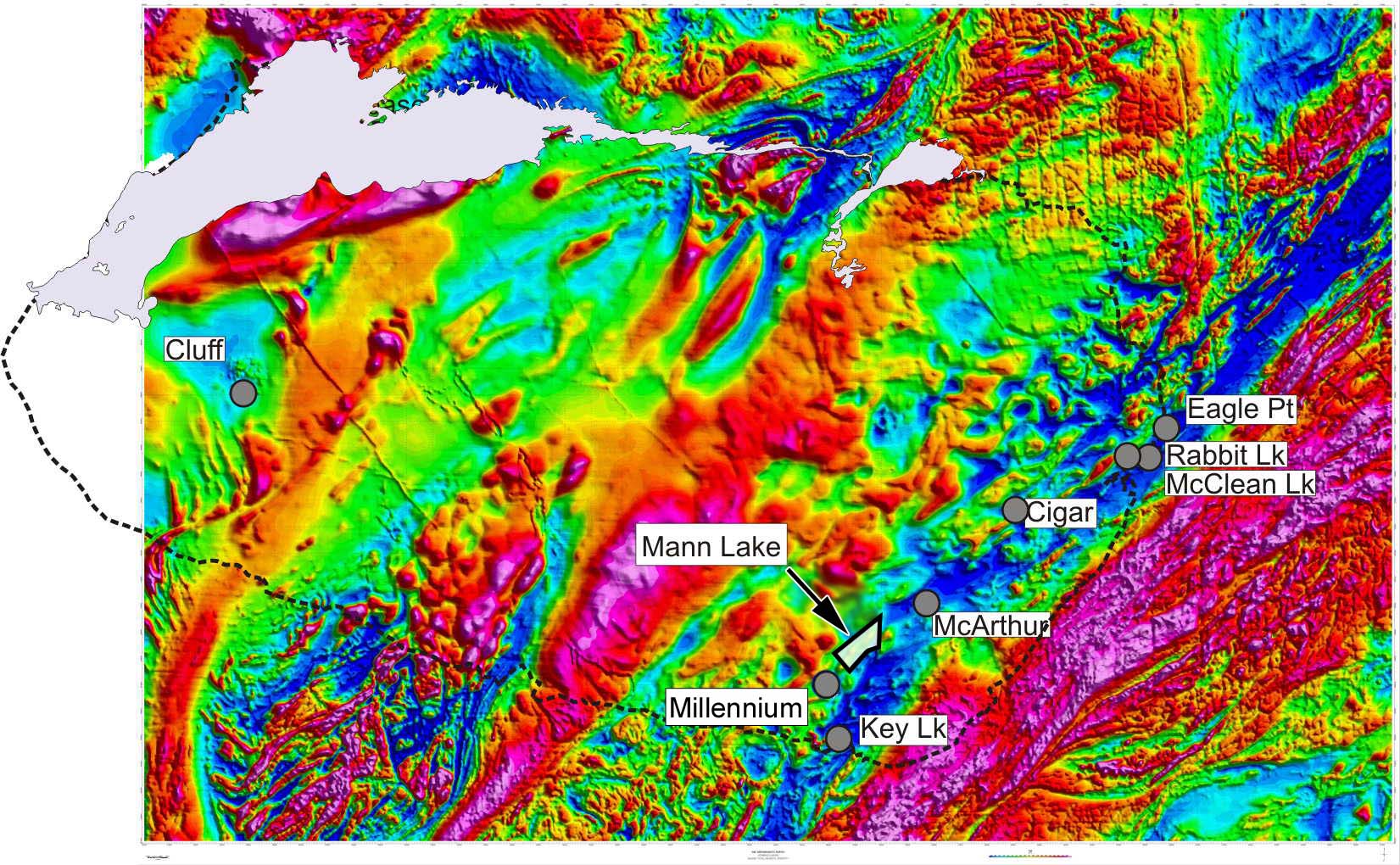
Athabasca Basin: 25 km southwest of the McArthur River Mine
Project Overview
The 3,473-hectare (8,582 acre) Mann Lake Uranium Project is located in the eastern Athabasca Basin in northern Saskatchewan. It is strategically located 25 km southwest of the McArthur River Mine, the largest high-grade uranium deposit in the world, and 15 km to the northeast along strike of Cameco’s Millennium uranium deposit. In October, 2021 the Company entered into an option agreement with Skyharbour Resources Ltd. to acquire up to a 75% interest in the Mann Lake Uranium Project.
Under the Option Agreement, Basin Uranium Corp will contribute cash and exploration expenditure consideration totaling CAD $4,850,000 over a three-year period (“Project Consideration”). Of the Project Consideration, $850,000 will be in cash payments to Skyharbour and $4,000,000 will be in exploration expenditures on the project. Basin Uranium Corp will also issue to Skyharbour the equivalent value of CAD $1,750,000 in shares of the company over the three-year earn-in period to complete the earn-in.
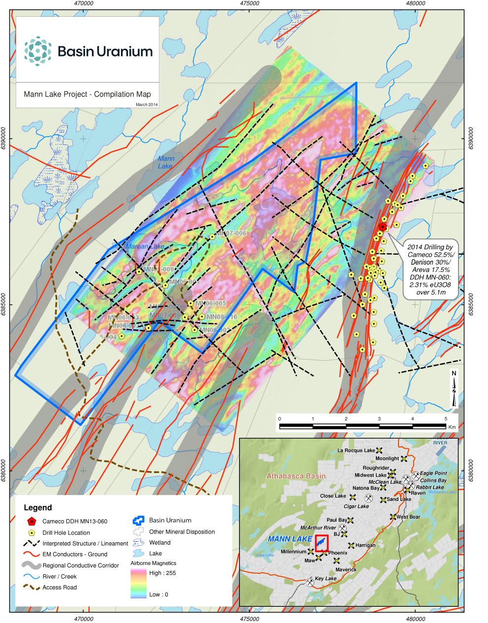
The Mann Lake property is also adjacent to the Mann Lake Joint Venture operated by Cameco (52.5%) with partners Denison Mines (30%) and Orano (formerly AREVA) (17.5%). In 2014, Denison Mines acquired International Enexco and its 30% interest on this adjacent project after the 2014 winter drill program discovered high grade, basement-hosted uranium mineralization. The drill program intersected 2.31% eU3O8 Over 5.1 metres including 10.92% eU3O8 Over 0.4 metres (see International Enexco News Release dated March 10th, 2014).
Previous Exploration
The Mann Lake Uranium Project has seen over $3 million of previous exploration expenditures including recent geophysical surveys and two diamond drill programs totaling 5,400 metres. The geophysical surveys identified basement conductors and structural corridors containing reactivated basement faults which trend onto the adjacent ground held by Cameco. Subsequent drilling intersected a 4.5-metre-wide zone of anomalous boron (up to 1,758 ppm) in the sandstone immediately above the unconformity in hole MN06-005. Boron enrichment is common at the McArthur River uranium mine, and along with illite and chlorite alteration, is a key pathfinder element for uranium deposits in the Basin. In the same drill hole, an altered basement gneissic rock with abundant clay, chlorite, hematite and calc-silicate minerals was intersected about 7.6 metres below the unconformity and contained anomalous uranium up to 73.6 ppm over a 1.5 metre interval. Background uranium values are commonly between 1 and 5 ppm.
Historical Exploration
In 1977, the Mann Lake property was staked by Saskatchewan Mining Development Corporation (SMDC, now Cameco Corp) as part of the larger Cree Extension Project. SMDC conducted exploration work almost continuously with various joint venture partners until 1989.
A regional hydrothermal corridor containing illite, dravite (boron) and chlorite alteration minerals was defined in the mid 1990’s based on the analysis of thousands of samples of drill core and surface boulders from the Cree Extension Project. The Mann Lake property is ideally situated in the heart of this corridor.
The property was optioned by Uranium Power Corp. and Pacific Amber Resources Ltd., who in 1999 conducted a reconnaissance, fixed loop TEM survey which detected four anomalies thought to indicate possible basement conductors.
In 2005, Triex optioned the property from Consolidated Abaddon (now Aben Resources) and undertook a detailed ground geophysical survey to further delineate drill targets.
In 2006, a first phase diamond drill program consisting of five holes was completed totaling 3,510 metres. Pervasive illite clay alteration was intersected over 90 metres of sandstone immediately above the unconformity in hole MN06-002. A 4.5-metre-wide zone of anomalous boron (up to 1,758 ppm), was intersected in sandstone immediately above the unconformity which occurs at 631 metres in hole MN06-005. In the same hole, an altered basement gneissic rock with abundant clay, chlorite, hematite and calc-silicate minerals was intersected 7.6 metres below the unconformity and was found to contain anomalous uranium (up to 73.6 ppm) over a 1.5 metre interval. Background uranium values are between 1 and 5 ppm. Both drill holes were located near an east-west fault.
A follow-up diamond drilling program consisting of 1,877 metres in three holes was completed in 2008 and a number of identified targets have yet to be drill tested.
In 2014, Skyharbour carried out a ground-based EM survey focused on a zone where a favourable, 2 km long aeromagnetic low coincides with possible basement conductor trends indicated by prior EM surveys. The survey was successful in confirming the presence of a broad, NE-SW trending corridor of conductive basement rocks which are probably graphitic metapelites.
Basin Uranium is initiating the permitting process for follow up drilling along the conductor trends. The Company also plans new ground EM surveys to further defined the conductors and drill targets.
Tim Henneberry, P.Geo, consultant to for Basin Uranium is the Qualified Person as defined by National Instrument 43-101 and has approved the technical information on this website.