Project Phase:
Advanced Exploration
Commodity:
Uranium
Size:
3,037 acres
Location:
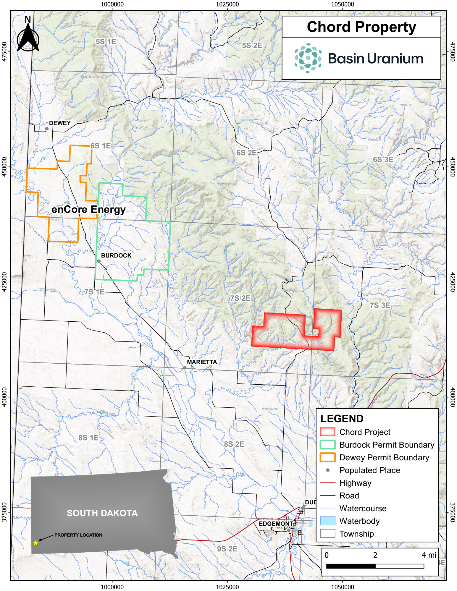
Fall River County, South Dakota
Project Overview
The Chord property is comprised of 147 contiguous lode mining claims (~ 3,037 acres) located in Edgemont, South Dakota approximately 3 miles southwest of encore Energy Corp.’s (NYSEAM:EU) Dewey-Burdock development project which is targeting initial production in 2025.1 Mineralization at Chord is hosted within typical roll front deposits in the Cretaceous age Fall River and Lakota formations, in particular the Chilson member which is the same host for mineralization at Dewey-Burdock. The property has been the subject of extensive exploration since the 1970’s with over 1,000 holes drilled by Union Carbide Corp. (“UC”) which led to the tabling of an internal resource and feasibility study.
enCore Energy’s adjacent Dewey-Burdock project is host to a M&I resource of 17.1 Mlbs U3O8 (7.4 Mt at 0.116% U3O8) plus an Inferred resource of 0.7 Mlbs U3O8 (0.6 Mt at 0.055% U3O8), a positive Preliminary Economic Assessment (PEA)2 outlining a low-impact in-situ recovery (ISR) operation producing 14.3 Mlbs U3O8 at an all-in sustaining cost of US$28.88/lb U3O8. The Dewey-Burdock project also has received its Radioactive Materials License (RML) from the U.S. Nuclear Regulatory Commission (NRC) and is currently navigating the State Licensing process.
Basin is acquiring a up to a 90%-interest for a total of US$50K in cash, US$950K in stock, and US$1.2M in exploration with the timing dependent on the receipt of permits from applicable regulatory authorities in accordance with the terms of the Option Agreement (see March 3rd, 2023 Press Release).
1 enCore Energy February 2023 Corporate Presentation “enCore: production pipeline”
2 Azarga Uranium NI 43-101 PEA dated December 22, 2020
Mineralization
Historic Resources
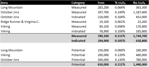
- October Jinx: Mineralization lies in the Chilson member, is unoxidized and lies at depths varying from 400 to 500 feet. Resources were based on 100-foot drill hole spacing except for three areas that were drilled on 500-foot offsets to test the continuity with results showing good continuity of mineralization. A cutoff grade of 0.06% U3O8 and a minimum grade thickness product (GT) of 0.30 was used and diluted to a minimum width of 8 feet.
- Ridge Runner & Virginia C: Mineralization lies in the Fall River Formation with sallow depths of less than 50 feet. Resources were based on drill spacing of 50-foot or less with chemical assays of 2 foot samples of rotary drill cuttings (where available) and radiometric results. A cutoff grade of 0.04% U3O8 and a minimum grade thickness product (GT) of 0.08 (2.0 feet of 004% U3O8) was used and diluted by 30% of 0.02% U3O8.
- Viking: Mineralization lies in the Lakota formation and accessed via a decline in a gulch west of the deposit. Resources are based on 100-foot drill hole spacing and chemical assays of 2 foot samples of rotary drill cuttings. A cutoff grade of 0.04% U3O8 and a minimum grade thickness product (GT) of 0.30 was used and diluted to a minimum width of 8 feet.
- Long Mountain: Mineralization lies in the Chilson member and generally shallow varying from 60 to 150 feet to a maximum of 200 feet deep. Resources are based on 50-foot drill hole spacing and chemical assays of 2 foot samples of rotary drill cuttings. A cutoff grade of 0.04% U3O8 and a minimum grade thickness product (GT) of 0.08 (2.0 feet of 004% U3O8) was used and diluted by 30% of 0.02% U3O8. The claims under option cover 90% of the Measured and Potential historic resources at Long Mountain.
- Resource Modelling: Measured resources drilled on 50-foot centres were computed using the Polygonal Block Method. Measured resources drilled on 100-foot centres were computed using 300 tons per foot of ore intercept. Indicated resources were derived by subtracting the measured resources from the total resources computed by using the standard formula which relates the ratio of ore holes to total holes of the volume of the area of equally-spaced drilling. Potential resources were based on projections of favorable ore-bearing formations. Density tests have been run on Lakota ores mined from Long Mountain and on core samples taken in 1978. The density used to compute the Chord resources was 14 ft3 per ton and Fall River resources are computed using 15.5 ft3 per ton.
Adjacent Projects
- Dewey-Burdock Project located 3 miles SW of Chord is owned by enCore Energy Corp (NYSEAM:EU)
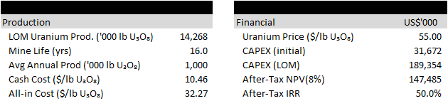
- Project is host to a M&I resource of 17.1 Mlb U3O8 grading 0.116% U3O8 and Inferred resource of 0.7 Mlb grading 0.055% U3O8.4
- A December 2020 PEA5 outlined life-of-mine (LOM) production of 14.3 Mlb U3O8 over a ~16 year mine life (steady-state production of 1.0 Mlb U3O8/yr) at a cash cost of US$10.46/lb U3O8 and all-in cost of US$32.37/lb U3O8. Using a uranium price of US$55/lb U3O8 and initial CAPEX of US$31.7M (US$189.4M LOM), the project generated an after-tax NPV8% of US$147.5M and IRR of 50%.
- enCore has publicly stated initial production targeted for 2025.6
- The project has received its Radioactive Materials License (RML) from the U.S. Nuclear Regulatory Commission (NRC) and is currently navigating the State Licensing process.
7.https://frcheraldstar.com/news/3940-fifty-six-percent-of-voters-say-uranium-mining-is-nuisance
Historical Exploration
Uranium was discovered in the southern Black Hills in 1951. Shortly after the Atomic Energy Commission (AEC) established an ore buying station in Edgemont, South Dakota. Mines Development Inc. began a milling operation in 1956.
The claims that make up the Chord today were discovered and mined in the 1950’s. The property is eight miles north of Edgemont, S.D. Production came from a large number of small deposits in both the Fall River and Lakota Formations.
Union Carbide purchased the Chord property in 1974. Exploration on the property led to a number of new mineralized areas being discovered. Baseline environmental and studies were conducted and a mine construction firm was hired to drive a 2,000 foot exploration decline into the October Jinx orebody.
In 1982, the property was leased to American Gold Minerals. Ultimately, the uranium market declined to the point where Union Carbide elected walk away from their South Dakota properties.
Strathmore Resources acquired claims covering the majority of known mineralization in 1998 and additional surrounding claims were staked during the mid – 2000’s uranium cycle by Tournigan Energy, Denver Uranium, and Neutron Energy.
Tim Henneberry, P.Geo, consultant to for Basin Uranium is the Qualified Person as defined by National Instrument 43-101 and has approved the technical information on this website.